")
Glacier National Park-Outrider John Cox
Glacier National Park II
With Outrider: John Cox
My next Happening outrider is no stranger to Ruck Rolling. John has been on many adventures with me. We have skied from the Swiss Alps to Whistler BC. Cruised to exotic islands, flown hang-gliders, raced convertibles, rocked Harleys, jet skied glass, smashed class IVs, climbed rocks, sailed yachts, joy-rode choppers, wrangled rattlers, smuggled gators, encountered bears, buffalo and bald eagles while hiking countless miles chasing waterfalls and summits under many star-lit skies and that hardly scratches the surface of the long list of existential bliss we have experienced in the company of one another. John is my Brother in this life and there is no one I enjoy adventuring with more. We are both creative, artistic, musical and business savvy and share a thirst for adventure. As a team, we are capable outdoorsmen and have high expectations for our experiences and keep ourselves marvelously entertained. I hope to document some of our past excursions in future entries as they are all extraordinary memories. On this day however, new memories were being formed and his flight landed right on time. This wasn’t our first trip to Montana together. We took in some white water on the Gallatin, yachted Hebgen Lake and bagged a peak near Big Sky years ago on another expedition while also exploring Yellowstone and Tetons National Parks. I am very familiar with the area as Lone Mountain in Big Sky is one of my favorite ski destinations. I have been many times and hit Yellowstone on numerous outings yet I never ventured North of Bozeman until my arrival last week. This was to be John’s first jaunt in Glacier as well so I was glad to have had some time to explore and become more familiar with the area before his arrival. Once we linked up at the airport, we drove to the rig and went straight into planning and prepping. Going to the Sun road had opened the day before. We now had full access to the roadway intersecting the park. First thing in the morning, we were hitting it full force with a twelve miler and several thousand feet elevation gain and loss on the parks crown jewel at Logan Pass.
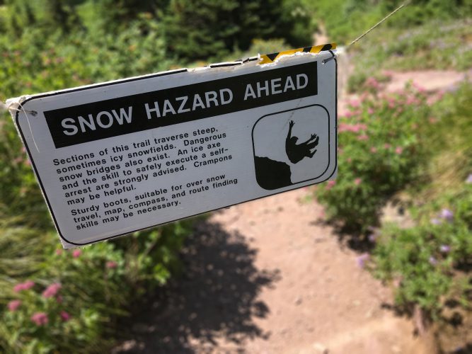
Highline Trail is etched into a cliff face running along the Continental Divide on a span known as The Garden Wall. The trailhead is located at Logan Pass which is the central point of the park and the location of the main visitor center. We arrived early to avoid the crowds which were already flowing in before seven. We geared up and started to the trailhead when we encountered several hikers walking in the other direction. One stated that the trail was closed. We rounded the corner and could see a park ranger standing in front a roped trail indicating the trail was indeed closed due to dangerous conditions.
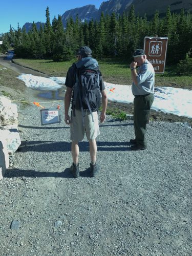
Ruck uses the Jedi Mind Trick
Photo Credit: John Cox
I felt my heart sink as we had a meticulously planned week with permits involved. I was ready to feel the burn of some miles and consider myself a man of some danger with sound judgement. Sign be damned, I wanted this route. As I approached, the ranger was putting away his radio and I took a desperate stab at wit and asked him “that head-quarters letting you know its ok to open the trail for the hardcore and capable?” He looked at me directly and said, “why yes sir it was.” He unbuckled the rope and said “Be careful since you’re the first people on the trail this season. bears have been active…bypass the four additional rope closures along the way”. John and I picked up our jaws and regained our composure. We began walking in earnest as if the ranger might change stripes and call us back. I looked at John and asked “did that really just happen?” It happened! We were the first hikers on the most scenic trail in the park and had first shot at all the undisturbed wildlife emerging from its winter slumber. Quick review of bear protocol. We both had spray so whoever got gnawed on like a pork tenderloin was in charge of ass-saving and counter-assault. The other was responsible for video documentation. Relevant duties in place, we hit the dirt with purpose.
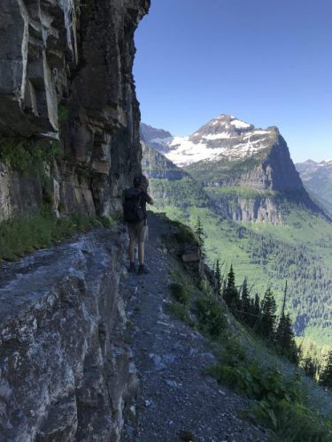
Navigating the ledges
Photo Credit: John Cox
The views were immediately expansive and spectacular as we wound around a valley towards a narrowing ledge overlooking Going to the Sun below. We joked at the parks expectation that hikers know how to stay upright and subsequently on the sparse trail afforded. With only two to four feet of width at any given point, Going to The Sun Road lurks below a sheer six hundred-foot drop and Piegan Peak and the Bishops Cap loom thousands of feet above. A garden hose is bolted along the wall for a hand-hold that we chided and refused to consider. We were no more than a quarter mile in when we encountered a rather bold Hoary Marmot. Hoary became a quick pun when the little damsel gave us a literal photoshoot and took a shot at sampling Johns boot laces. She went on to lead our hike skirting along the ledge for another quarter mile before we left her behind, forlorn, overlooking the traffic below. To say we bonded would be a bit of an understatement. I have not seen many wild animals with such a lack of fear. Particularly since we knew she had not been accustomed to humans since the last summer season at least. It turns out, most of the animals in Glacier seem relatively undeterred and unbothered by the wilderness tourists which made for wondrous sightings and interactions.
Glacier National Park Hoary Marmot
Shortly after we left the marmot, I felt the ground begin to shake. It only lasted a few moments but I was certain I felt it. I asked John and he had not. I began to think I had spent too much time in Colorado indulging Deathstar Cavier and pushed it from my mind. I learned a week later, a 5.8 had rocked West Montana…my mind raced. We could have been knocked off the ledge, the trail-ledge could have cleaved away, stone and debris could have fallen from the cliffs above…how dramatically cool! But the reality occurred without much fanfare and John didn’t even notice…but another unexpected bucket list item resolved: Hike on cliff ledge during earthquake with flirtatious Hoary Marmot. Check.

We continued along the route taking in vista after scenic vista. It was an incredible hike that offered the best of everything Glacier had to offer. What was particularly interesting was that we were scheduled to be on the opposite side of the range we were currently traversing affording views on both sides of the looming Mount Gould and Granite Park. The week prior, I had been on the third side of the mountain. We reached the peak of Granite Park and picked up a new path towards the trailhead located in a switchback on the main road known as “The Loop”. We began to descend the over three-thousand-foot elevation loss before our pullout when we noticed quite a few packers had opted to start at the other end of the trail. We had left the Titan at Logan Pass with intentions of catching the newly opened free shuttle service offered by the park and to exploit the minor one-thousand-foot gain required. This made an effective use of the downhill versus the three- thousand-foot gain encountered from a start from The Loop. These hikers had a few thousand feet of gain left to go and many of them looked like they could suffer heart failure at any moment. They certainly did not seem to be enjoying themselves in the slightest. I wasn’t sure if I should be impressed or pity whatever untrained effort they were making with poorly packed rucks and pots clanging from the side. Aside from proper gear, smartly packed rucks and some semblance of trail etiquette, you can always tell a true adventurer by the look on his face during “the suck”. Even amidst the agonizing pain of blisters, cramps, kinks and burns…there is always a silly shit-eatin’ grin on an adventurer’s face. I used to tell people who sailed with me to watch the skipper. If he is smiling, it doesn’t matter if we are sinking, it’s all good…he still has a failsafe and wait for instructions. If he is not smiling…worry…there is no plan! Perhaps these folks didn’t know what they were getting themselves into but we both found it highly unlikely a few would make it into the summits and at least one divorce was imminent. I applaud their effort but a little back country training and education would be very beneficial and more importantly, safer. Aside from poor pack jobs, we saw a surprising number of solo hikers with no gear at all. No water and no bear spray on ten-milers. Even with my experience, I had a wakeup call in Utah with dehydration doing the same (See Arches/Canyonlands). I also have no fear of animals but practicality dictates a few minimal precautions. Spray and water may seem cumbersome but I understand more fully who it is I read about when the unexpected does happen to strike and I think, who are these people? Usually, the Unprepared. Myself included if I ignore the conventional wisdom gleaned from the short-sighted and unfortunate. Got to learn somehow, right? The outdoors is not a great place for trial and error, guess-work or luck and we have learned a great deal. Trail etiquette can also be crucial for safety when steep terrain or scree is involved. There is an accepted set of standards among serious back-country explorers. Its not officially documented but can be found with numerous resources. Some are more common than others such as Leave No Trace. While others are commonly ignored like share the trail, yield to ascending hikers, be prepared. When in Rome…Google what the hell Romans do and do that, eh! Rant complete, we emerged from the woods and had a short wait for the shuttle. Soon, we found ourselves back in the Titan and on the road towards camp. We were both breaking in new Zamberland boots and had a down day planned to recover and see how we felt while we planned our next hike: Grinnell Glacier. The one hike I was determined to do on my great excursion and it exceeded every expectation as one of the best hikes I have experienced.
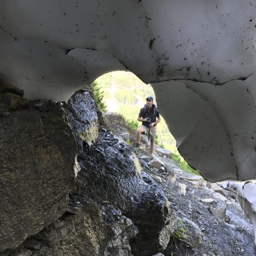
Features changed from moment to moment
Photo Credit: John Cox
Similar to our experience on the Highline trail, there is a truth when it comes to the back country: conditions matter. Expansive views of mountains commonly stir the senses but it’s the other nuances of the environment that bring a place to life and make for magical excursions or the bane that drives you back to civilization. A bright sun and huge, shape filled clouds in a blue sky. The amount of snowfall lending white to otherwise brilliantly colorful landscape of evergreens, wild flowers and turquoise waters. The level of snowmelt that propels the falls and nourishes the lush new blooms. The evidence of wildlife and vibrancy of new and emerging life. Or perhaps a torrential downpour on an exotic shore, lightning on a ridgeline? Picture perfect unless you’re on the ridgeline too. Perhaps the most likely negaitive occurrence is that of trail-Jerrys running rampant in your midst. These factors can make or break a hike. Waterfalls during a drought lack their splendor. Gorgeous lakes during mosquito season are a wash. Too many people and the mysticism vanishes. I think you get my point in that you could hike the same hike on numerous occasions and each experience will be somewhat unique. Mediocre or amazing can occur in the same place. I seriously doubt Grinnell Glacier trail could ever be considered mediocre by any standard but on this particular day, we caught Grinnell at one of the most amazing times and an epic memory was etched in the annuls.
We started early and reached Many Glacier just after seven. Lake Sherburne had been rocked by whitecaps for the last few weeks. The Ranger at the station had said most kayakers avoided it due to this fact. This morning it was glass. Hardly a ripple. John pulled off a few shots and we found easy parking and made for the trailhead.
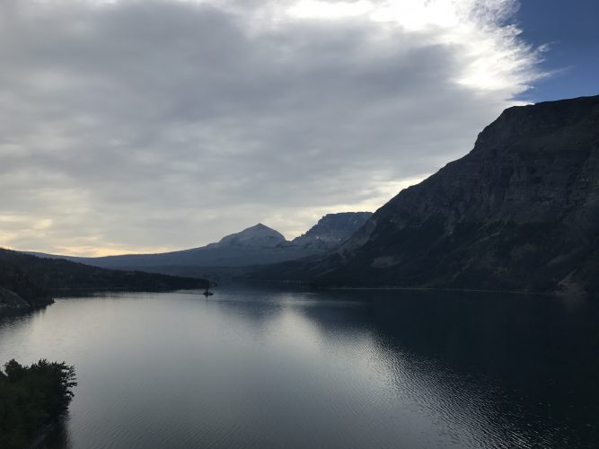
Lake Sherburne
Photo Credit: John Cox
It did not take us long to overcome most of the other hikers and had reasonable solitude for the entire route. The first part of the hike was not unlike Iceberg Lake. Jaap and I had had hiked the same trail then diverted a few miles to the east and north just a week before. We skirted Switchcurrent and Josephine lakes before beginning an ascent into alpine meadows overlooking both lakes. Before long, Grinnell lake also appeared in the valley below. Fed by numerous robust waterfalls descending from the glacier’s edges. It was beautiful. The water was a striking turquoise and shimmered like diamonds in the light breeze. We had to take it slow as the view was so breathtaking and the trail so narrow that it would be easy to simply walk off the lip of the path and tumble about a thousand feet down a rather significant slope. We rounded the corner to an expansive view of numerous falls, the glacier suspended in the ledges above and all three lakes in a linier path. Several dozen hikers were posted up eating snacks and taking in the view. A sign and rope blocked the trail ahead here as well. We asked if they had seen anyone venture on and they said there had been a few. We could see two hikers in the distance foot testing a snowfield crossing a steep portion of the cliff side. After a few feeble steps, they returned giving up.
John and I ducked the rope and headed up the trail which was terminated by the flow of glacier melt pouring through a washout creating a rapidly-flowing creek. We navigated up the slope a bit to maneuver across a set of falls with solid rock toeholds. We picked the trail back up and were again stymied by a large fall dumping directly on the trail and over the edge. It was a significant amount of water and could likely knock a man from the ledge so we opted to drop down the slope and again navigate to an area we could cross. The trail in this area was completely covered by snow so we had go class 4 and a little light 5 to scale some rocks to an outcropping where we took a break. I dangled my feet off the edge and we looked down at the tiny people below. Several had their cameras out directed at us during our snowfield crossing and climb. We both knew every one of them was wishing they were sitting where we were at that moment: on top of the world.
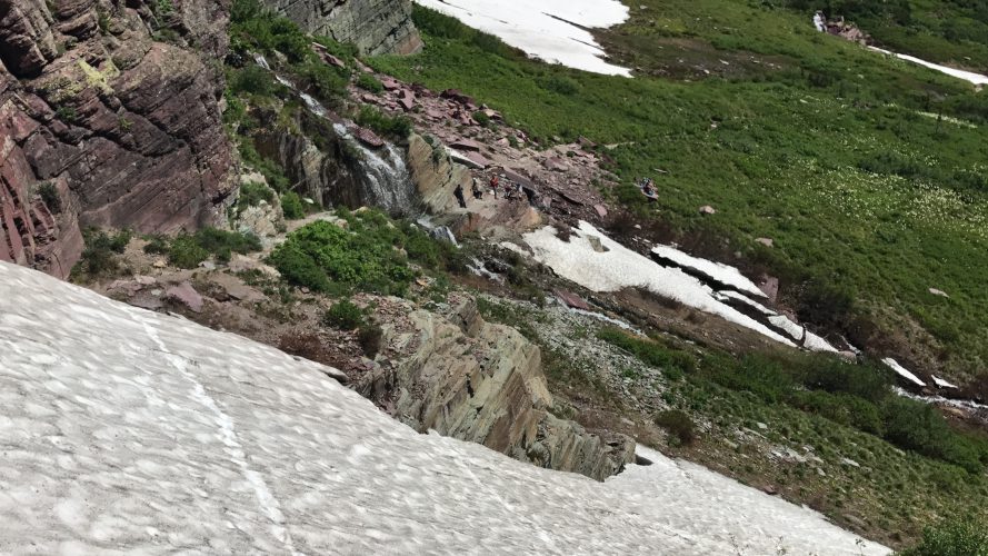
Overlooking the route. Far top right is the first fall crossing. Falls in the middle covered the trail so we ducked below. We in came across the snowfield and up the rocks
As we were scoping the landscape, I spotted a large bull-moose cooling off in a creek bed. We watched him for several minutes as he drank and grazed and then relinquished our heavenly perch to drive on. The trail was nonexistent from there on out and we set out through the thickets. We knew there were several lakes on the map that we had not reached and had little fear of getting disoriented. Down was the only real direction available to end up. We encountered several more marmots on this route, including a mother carrying her youngster inverted up a snow filed. The interactions and view passed the miles like time had ceased. We carefully assessed and crossed numerous snowfields and scrambles and eventually scaled over a ridge where the rocks opened into a breathtaking stone amphitheater. The lake was dark blue and still frozen. The glacier edge poured into the South portion of the lake and a waterfall spewed a hundred feet from the center of the looming rock face and dropped into the lake edge behind the ice. It was an awe-inspiring sight. The upper lake was twice the size of Iceberg Lake and the cliffs as formidable. It was impossible to photograph either in entirety. The sections look small in pictures but in reality, made us feel minuscule. There were no trees within the mountain niche so we sought refuge in the scrubs. We both had a bit of sunburn from the days before and the rays were beaming. We had lunch and were amused by a pika who was none too happy to see us and I am certain John was sitting on the entrance of his hole when the furball circled him in close proximity numerous times. We cleaned up our spot yielded the land to the pika and reluctantly headed back down the trail which afforded another round of the beauty-saturated landscape. We spotted the bull-moose again on our return. He had moved from the creek down to the end of Grinnell lake several miles down. The black beast was easy to spot against the light blue backdrop of the water. It was knee deep in the shallows of the lake, taking in another moment by itself. The majestic animal disappeared behind the trees as we dropped back into the forest along the trail towards Jospehine lake and on to the truck. Fulfilled and nostalgic, we drove the switchbacks through the park. We rounded a corner and were forced to slam on the breaks to avoid missing a herd of horses who had decided to take a lounge in the center of the road. The animals refused to budge and the traffic in the oncoming lane seemed quite befuddled and car doors began to open and camera shutters snap. We slowly meandered through the herd using both lanes and emerged amused at the gawkers. I figured they mistakenly assumed the large, well-fed, open range equines were wild mustangs. Or maybe even the sought-after Many Glacier cow (see glacier 1). Perhaps they were the fabled stallions of a mystic past. I was just glad that it was a short delay and we didn’t get caught in the forming horse-jam.
We had obtained a back-country permit for the following evening. We had planned to hike to Cobalt Lake, named and known for its deep blue color. We were to take in several falls along the way and overnight at the lake. We were on track until the ranger station called and said the site had been overbooked and that we could share or change dates. We were disappointed and the situation was very odd and the potential outcomes didn’t brighten our outlook. We quickly revamped our plans and relinquished the permit in exchange for a drive into the Northwest area of the park towards a trailhead of a hard-core thirty-two miler I would like to do someday. At the crack of dawn, we returned to Avalanche Lake and Monument Falls. I knew the seven-mile round trip hike was worthy and we were on the trail with the dawn. We were some of the first to reach the lake and like me an Jaap, we worked around the edge away from the area where hikers seemed to congregate. We were able to make it across the delta flows that me and Jaap had scouted and bypassed the week before. Once on the beach of the far side, we had relative solitude for around an hour and simply relaxed and took in the light rays cast by the rising sun. It didn’t take long for our enviable sanctuary to be invaded by other hikers. Where one leads the way, the rest will follow. We loaded up our protein bar wrappers and head across the rivulets back to the trail and made our journey home. John’s flight was the next morning and recovery was required so we resigned to responsibility and prepared for his departure. I saw him off to the airport and made my way back to Lake Five where I spent some time conversing with Ron and one of his team. We shared stories of thrills and adventures and revered friends lost along the way in the pursuit of an extraordinary life. Turns out, we had a great deal in common after some exchange of history. I hope we meet again someday but it was time for me to push West. More adventure awaits at the farthest Northwest reach of the Lower 48, Cape Flattery on the Olympic Peninsula in the State of Washington.

Sunset at Lake Five
Carla Cox
Amazing photos, amazing experience!! Gifted writer and story teller!!